Grottes et karsts de Chine
Sur les traces de Xu Xiake
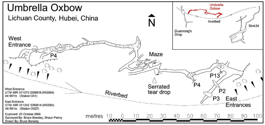
 Umbrella Oxbow -
Détail
Province, Préfecture, District :
Hubei 湖北省, Enshi 恩施土家族苗族自治州, Lichuan 利川市
Latitude Nord - Longitude Est :
30.355492 - 109.034291
Altitude (m) : 987
Développement (m) : 261
Profondeur (m) :
Profondeur - / + (m) : 0 /
Volume (m3) :
Géologie : Trias inférieur (Jialingjiang) T1j , (Daye) T1d
Carte
Description 0
Bibliographie 2
Compiled by Bruce Bensley, Ged Campion, Mike Clayton, Tony Harrison and Emma Porter (2008)
Lichuan 2006. Lichuan Expedition 2006 The 20th China Caves Project Expedition to Hubei & Jiangxi Provinces. Published by British Cave Research Association (BCRA). 145pp.
Rapport d’expédition 2006 dans les provinces du Hubei (Lichuan) et du Jiangxi 145pp, 107 photos couleurs, 10 cartes, 37 topos et synthese topo, tableaux de résultats spéléologique...
Source :
Gerard CAMPION (2011)
Tenglong Dong and the caves of Lichuan County, Hubei, China. CAVE AND KARST SCIENCE, Vol.38, No.2, 2011 © British Cave Research Association 2011. Transactions of the British Cave Research Association ISSN 1356-191X.pp 61.64.
Source :
Images 0
Topographie 1

Source : CCP
Expédition 1
Cette grotte a été identifiée ou explorée au minimum par cette (ces) expédition (s) :
Recherche