Grottes et karsts de Chine
Sur les traces de Xu Xiake
 Furongdong - 芙蓉洞
Détail29/03/2025 10:18:51
Province, Préfecture, District :
Chongqing 重庆, , Wulong 武隆县
Latitude Nord - Longitude Est :
29.22927 - 107.903469
Altitude (m) : 433
Développement (m) : 1 846
Profondeur (m) :
Profondeur - / + (m) : 229 /
Volume (m3) :
Carte
Description 1
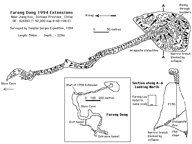
Furong Dong show cave is a major relic resurgence cave modified by collapse and speleothems. The main show cave terminates in a huge boulder pile, but a small passage leads south through a crawl and down into a side passage with a very different character. The massive speleothems of the show cave are absent and the floor is covered with aragonite needles. A crystallised bat skeleton, some large bones and some teeth from a panda were discovered beneath a climb that leads into the extension. The extension is a relic phreatic passage, approximately 15 to 20 m wide, that is developed along the strike of beds dipping to the east at about 40 degrees. Aragonite crystals cover the floor and walls, and chandelier-like cluster of crystals hang from the roof. At the southern limit the passage Is blocked by a stalagmite flow fed from a roof inlet. The passage probably continues beyond this blockage. On the eastern side of the final chamber, however, a huge pit drops 200m into a fault-bounded chamber. The top of the pit is completely covered by stalactites and curtains, descent requiring the use of thread belays through curtains. At the bottom a mud slope drops 30m to a clean washed boulder choke. In wet conditions water rises here and backs up into the chamber. Unfortunately, all ways on are blocked.
YGE94 p68(S),73
Analyse :
1325 caractères - Lu 218 Fois
Bibliographie 2
SENIOR, Kevin J. (ed.) (1995): The Yangtze Gorges Expedition: China Caves Project 1994.-
Cave and Karst Science vol.22 no.2 / Oct 1995: 53-90. (maps. photos. surveys).
This was the latest in a collaborative expedition involving British speleologists and karst scientists from the Institute of Karst Geology in Guilin. This paper presents the results of exploration in four study areas within Sichuan Province and 13.5 km of cave passages were surveyed. The Xio Zhai Tien Ken to Mie Gong He Dong cave system, a 4.5 km through trip, is the deepest cave in China at -964 m and the Xio Zhai Tien Ken doline is probably the largest doline in the world at 135.3 million cubic metres (both Xin Long area). Xin Lou Kou dong (Jiang Kou area) is -215 m deep; Lungci dong (Ba Xian area) has a length of 1.08 km. Hydrology and cave development are discussed and there is a brief note on cave conservation. (AUTHORS; RM; RB).
Source : BBS
ZHU, Xuewen (1994): [The speleothems in Furong Cave].-
Carsologia sinica, Vol.13 No.4 / Dec. 1994: 357-368 + 2 pag. with plates (2 tab., 4 figs., 23 colour. photos) (chinese; engl. summ.).
Description and survey of Furong cave. Morphology of speleothems, U-series ages of speleothems, and chemical properties of pool water are presented. Furong cave formed in Middle Pleistocene and then was followed by a period of fossil - cave evolution with a series of collapses. In the succeding period of last 160-200 ka, divided at least four stages, plentiful speleothems of calcite, gypsum, aragonite and hydromagnesite were accumulated. Survey, area map, plates. (RB).
Source : BBS
Images 0
Topographie 1

Source : Ccp
Expédition 2
Cette grotte a été identifiée ou explorée au minimum par cette (ces) expédition (s) :
Recherche