Grottes et karsts de Chine
Sur les traces de Xu Xiake
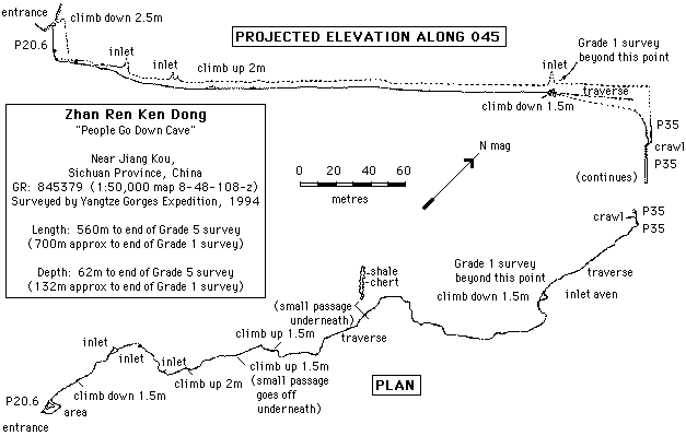
 Zuanyankeng - 钻研坑
Détail31/03/2025 15:08:03
Autres noms : Zhanrenkendong, People Go Down Cave
Province, Préfecture, District :
Chongqing 重庆, , Wulong 武隆县
Latitude Nord - Longitude Est :
29.224011 - 107.927052
Altitude (m) : 2011
Développement (m) : 2 012
Profondeur (m) : 209
Profondeur - / + (m) : 209 /
Volume (m3) :
Carte
Description 1
Close to Tianxing, about 50m down path towards the Furong Jiang in a small doline at the edge of a field, by a bamboo grove to the right of the path where it bifurcates and the route to D&o4;ng Ba goes to the right and down. The stream (dry Oct 2002) draining from the village is channeled into the entrance.
http://www.hongmeigui.net/
http://www.hongmeigui.net/
Analyse : Web
Site sur les campagne d’expéditions du club de Hong Mei Gui. Dans les provinces du Guizhou, Guangxi, Yunnan. Explorations dans les comtés de Leye, Nandan, Guilin. Données chiffrées sur les cavités topo données topo et photo chronique d’expédition.
308 caractères - Lu 206 Fois
Bibliographie 2
SENIOR, Kevin J. (ed.) (1995): The Yangtze Gorges Expedition: China Caves Project 1994.-
Cave and Karst Science vol.22 no.2 / Oct 1995: 53-90. (maps. photos. surveys).
This was the latest in a collaborative expedition involving British speleologists and karst scientists from the Institute of Karst Geology in Guilin. This paper presents the results of exploration in four study areas within Sichuan Province and 13.5 km of cave passages were surveyed. The Xio Zhai Tien Ken to Mie Gong He Dong cave system, a 4.5 km through trip, is the deepest cave in China at -964 m and the Xio Zhai Tien Ken doline is probably the largest doline in the world at 135.3 million cubic metres (both Xin Long area). Xin Lou Kou dong (Jiang Kou area) is -215 m deep; Lungci dong (Ba Xian area) has a length of 1.08 km. Hydrology and cave development are discussed and there is a brief note on cave conservation. (AUTHORS; RM; RB).
Source : BBS
http://www.hongmeigui.net/
http://www.hongmeigui.net/
Site sur les campagne d’expéditions du club de Hong Mei Gui. Dans les provinces du Guizhou, Guangxi, Yunnan. Explorations dans les comtés de Leye, Nandan, Guilin. Données chiffrées sur les cavités topo données topo et photo chronique d’expédition.
Source : Web
Images 0
Topographie 1

Source : Ccp
Expédition 3
Cette grotte a été identifiée ou explorée au minimum par cette (ces) expédition (s) :
Recherche