
Grottes et karsts de Chine
Sur les traces de Xu Xiake
 Gangzeidong 2/3 -
Détail21/03/2025 9:20:59
Province, Préfecture, District :
Guangxi 广西壮族自治区, Nanning Shi 南宁市, Mashan 马山县
Latitude Nord - Longitude Est :
23.612107 - 108.268080
Altitude (m) : 0
Développement (m) : 0
Profondeur (m) :
Profondeur - / + (m) : 0 /
Volume (m3) :
Carte
Description 1
Gang Zei 2
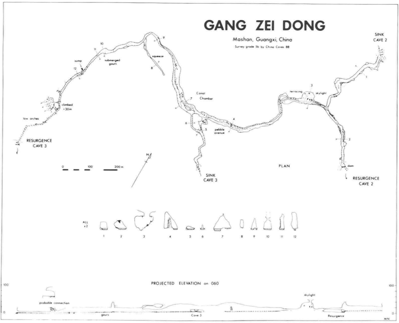
On the far side of the Li Long doline from the Gang Zei I resurgence, the river was followed through a low entrance (Figure 4) passage downstream using an inflatable dinghy for 300m to a large fossil side passage with a skylight. This led to Gang Zei 3. Evidence of a 'pebble avenue' leading to a large stalagmite boss with work steps up it showed that the cave had been entered and used, possibly for religious purposes, sometime in the past. A rise in water levels caused by irrigation systems in the doline nowadays restricts entry to those who don't mind getting wet.
Gang Zei 3
Exploring from the sink by dinghy a passage on the right after 150m was followed to the large fossil passage connecting with Gang Zei 2. The main routes joined a little further downstream in Canal Chamber. The now large stream passage with sand banks was then followed until the stream totally filled the passage. The high rift continued past waterfalls over drowned gour pools which seem to be the result of an irrigation dam at the resurgence. The rift then degenerated into a low canal with phreatic pendants. A hanging boulder choke with a strong draught was presumed to be associated with the huge fossil entrance directly above the rising in the Long Chuan doline. Roof level dropped to 1m just before daylight was reached downstream.
[Tim Fogg]
FOGG, Tim (1990) : Jin Lun Dong and the caves of Gang Zei, Mashan County, Guangxi.-
Cave Science vol. 17 nr. 2 : 67-70.
Analyse : BBS
In the Fengcong - karst area of SE Mashan Co. a total of 15 km of cave passages was surveyed. Jin Lun Dong is a multiple level system with an active streamway, totalizing 7 km. The six caves forming the Gang Zei River cave system totalize 7 km of active and fossil passages. (3 cave maps, speleol. area map, phot. (RB)
1346 caractères - Lu 172 Fois
Bibliographie 2
FOGG, Tim (1990) : Jin Lun Dong and the caves of Gang Zei, Mashan County, Guangxi.-
Cave Science vol. 17 nr. 2 : 67-70.
In the Fengcong - karst area of SE Mashan Co. a total of 15 km of cave passages was surveyed. Jin Lun Dong is a multiple level system with an active streamway, totalizing 7 km. The six caves forming the Gang Zei River cave system totalize 7 km of active and fossil passages. (3 cave maps, speleol. area map, phot. (RB)
Source : BBS
AA China Caves Project 1987-1988 (1989?)
Published by China Caves Project Edited by P & T Fogg
Rapport d’expédition spéléologique anglaise 1987-1988 dans le Guizhou et le Guangxi. 32 pp, 36 photos couleurs, 2 topographies.
Source :
Images 0
Topographie 1
Source : Ccp
Expédition 1
Cette grotte a été identifiée ou explorée au minimum par cette (ces) expédition (s) :
Recherche