
Grottes et karsts de Chine
Sur les traces de Xu Xiake
 Gangzeidong 1 -
Détail20/03/2025 19:18:33
Province, Préfecture, District :
Guangxi 广西壮族自治区, Nanning Shi 南宁市, Mashan 马山县
Latitude Nord - Longitude Est :
23.617028 - 108.268779
Altitude (m) : 230
Développement (m) : 0
Profondeur (m) :
Profondeur - / + (m) : 0 /
Volume (m3) :
Carte
Description 1
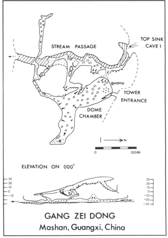
GANG ZEI DONG
This river sink lies on the southern side of the valley close to the village which gave the cave its name, Gang Zei. The cave (Figure 3) can be entered at river level or by the fossil entrance above which is visible from the road. The large active river passage can be followed on dry sediment banks and rock ledges, until the final 100m must be swum out to daylight in the doline of Li Long. Instead of entering the water, a route through small passages in the left can be followed upward to emerge in the large fossil chamber above. This can also be entered directly from the fossil passage above the sink.
[Tim Fogg]
GILL, Dave; LYON, Ben; FOWLER, Simon (1990) : The caves of Bama County, Guangxi, China.-
Cave Science vol. 17 nr. 2 : 55-66.
Analyse : BBS
Bama County contains a large hydrological system with associated caves, draining into the Pan Yang River, a tributary to the Hongshui. The Pan Yang cave system between Beimo Dong (main sink) and Fulong Dong rising was surveyed over 16 km, with passages as high as 145 m and 80 m in diameter. A total of 16 caves and 17 km of passages in Bama Co. were surveyed (10 cave surveys, area map, speleol.map, phot.). (RB)
633 caractères - Lu 132 Fois
Bibliographie 2
FOGG, Tim (1990) : Jin Lun Dong and the caves of Gang Zei, Mashan County, Guangxi.-
Cave Science vol. 17 nr. 2 : 67-70.
In the Fengcong - karst area of SE Mashan Co. a total of 15 km of cave passages was surveyed. Jin Lun Dong is a multiple level system with an active streamway, totalizing 7 km. The six caves forming the Gang Zei River cave system totalize 7 km of active and fossil passages. (3 cave maps, speleol. area map, phot. (RB)
Source : BBS
AA China Caves Project 1987-1988 (1989?)
Published by China Caves Project Edited by P & T Fogg
Rapport d’expédition spéléologique anglaise 1987-1988 dans le Guizhou et le Guangxi. 32 pp, 36 photos couleurs, 2 topographies.
Source :
Images 0
Topographie 1
Source : Ccp
Expédition 1
Cette grotte a été identifiée ou explorée au minimum par cette (ces) expédition (s) :
Recherche