
Grottes et karsts de Chine
Sur les traces de Xu Xiake
Grottes
 Macangdong
Détail2/01/2025 9:16
Province, Préfecture, District :
Guangxi 广西壮族自治区, Hechi 河池市, Bama 巴马瑶族自治县
Latitude Nord - Longitude Est :
-
Altitude (m) : 0
Développement (m) : 100
Profondeur (m) :
Profondeur - / + (m) : 0 /
Carte
Description 1
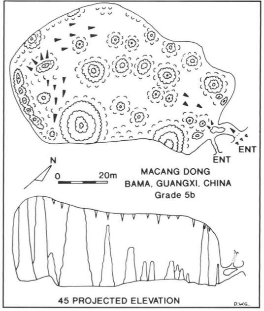
Macang Dong
Situated 3km north east of Bai-Mo village. At the end of the road a 10 minute walk to the north leads to the small entrance to Macang Dong. A large well visited chamber contained many large stalagmites completely blocked with flowstone (Figure 12).
GILL, Dave; LYON, Ben; FOWLER, Simon (1990) : The caves of Bama County, Guangxi, China.-
Cave Science vol. 17 nr. 2 : 55-66.
Analyse : BBS
Bama County contains a large hydrological system with associated caves, draining into the Pan Yang River, a tributary to the Hongshui. The Pan Yang cave system between Beimo Dong (main sink) and Fulong Dong rising was surveyed over 16 km, with passages as high as 145 m and 80 m in diameter. A total of 16 caves and 17 km of passages in Bama Co. were surveyed (10 cave surveys, area map, speleol.map, phot.). (RB)
260 caractères - Lu 296 Fois
Bibliographie 1
GILL, Dave; LYON, Ben; FOWLER, Simon (1990) : The caves of Bama County, Guangxi, China.-
Cave Science vol. 17 nr. 2 : 55-66.
Bama County contains a large hydrological system with associated caves, draining into the Pan Yang River, a tributary to the Hongshui. The Pan Yang cave system between Beimo Dong (main sink) and Fulong Dong rising was surveyed over 16 km, with passages as high as 145 m and 80 m in diameter. A total of 16 caves and 17 km of passages in Bama Co. were surveyed (10 cave surveys, area map, speleol.map, phot.). (RB)
Source : BBS
-- Images 0
Topographie 1
Source : Ccp
Expédition 1
Cette grotte a été identifiée ou explorée au minimum par cette (ces) expédition (s) :
Recherche