Grottes et karsts de Chine
Sur les traces de Xu Xiake
 Amingdong -
Détail25/02/2025 10:31:40
Province, Préfecture, District :
Yunnan 云南省, Deqen 迪庆藏族自治州, Zhongdian 中甸县
Latitude Nord - Longitude Est :
27.52355 - 100.05034
Altitude (m) : 0
Développement (m) : 36
Profondeur (m) : 16
Profondeur - / + (m) : 0 /
Volume (m3) :
Carte
Description 1
A ming dong
Location: On a hillside to the east of the village of Sanba. A steep walk down to the river is followed by another steep climb up the opposite mountain along a muddy track. After one hour, an area of limestone pavement is reached. The small entrance is hidden amongst the many clumps of trees. Local village guides are available. N27.52355◦, E100.05034.
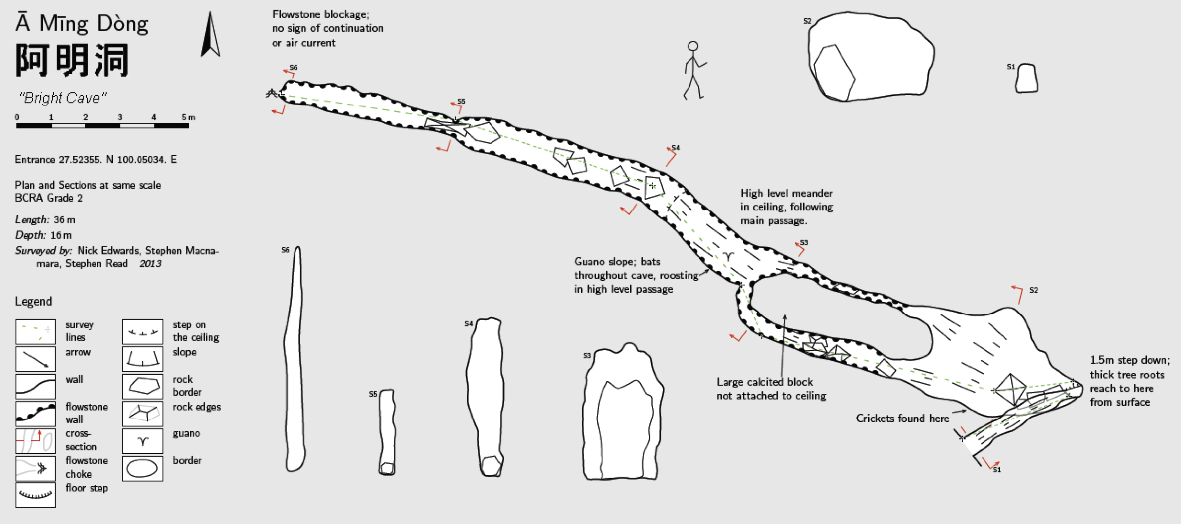
Description: The entrance is filled with large tree roots, which continue for several metres into the cave. The entrance tube quickly arrives at a vertical slot into a chamber with a sloping mud floor. A large mound of calcited rock lies in the centre of the chamber, and passage is possible along the left side. From here onwards, all surfaces are heavily calcited. The floor continues to slope down guano piles to reach a narrowing rift with a rocky floor. The end is blocked with flowstone and has little potential. The cave is dry and warm, and is inhabited by numerous bats.
Aut. Var. Ouvrage collectif. GAVIN LOWE Edited by
Haba Xue Shan Expedition. Cave expedition to Yunnan Province, China 24th August to 15th September 2013. 18p, 17 photos, 1 topographie, 1 carte
Analyse : gkc-JPB
Rapport d’expédition sur les flancs du Habaxueshan (Yunnan, Zhongdian) 5 cavités décrites dont une : Amingdong topographiée.
947 caractères - Lu 142 Fois
Bibliographie 1
Aut. Var. Ouvrage collectif. GAVIN LOWE Edited by
Haba Xue Shan Expedition. Cave expedition to Yunnan Province, China 24th August to 15th September 2013. 18p, 17 photos, 1 topographie, 1 carte
Rapport d’expédition sur les flancs du Habaxueshan (Yunnan, Zhongdian) 5 cavités décrites dont une : Amingdong topographiée.
Source : gkc-JPB
Images 0
Topographie 1

Source : O.U.C.C
Expédition 1
Cette grotte a été identifiée ou explorée au minimum par cette (ces) expédition (s) :
Recherche