
Grottes et karsts de Chine
Sur les traces de Xu Xiake
Grottes
 Qiandong 前洞
Détail23/03/2025 18:51
Autres noms : Cave in front
Province, Préfecture, District :
Guangxi 广西壮族自治区, Hechi 河池市, Bama 巴马瑶族自治县
Latitude Nord - Longitude Est :
24.317908 - 107.093577
Altitude (m) : 0
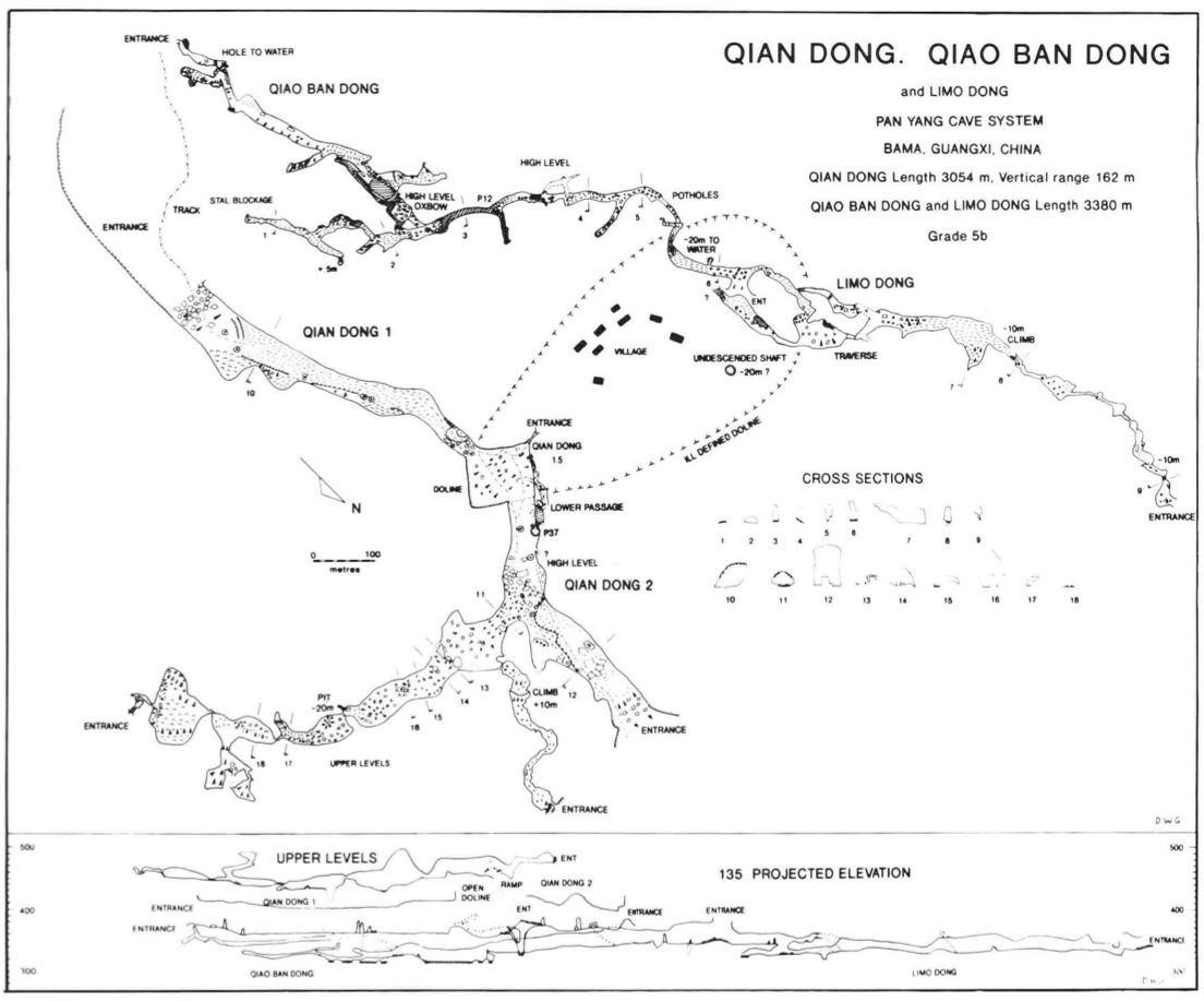
Développement (m) : 3 054
Profondeur (m) : 162
Profondeur - / + (m) : 0 /
Carte
Description 1
Qian Dong
Qian Dong ("the cave in front") was first sighted from the exit of Bai-Mo Dong and is in fact simply the continuation of that cave across a doline. The first impression on approaching from the south is of an enormous entrance arch which dominates the scene (Figure 6). A track leads in and continues right through the cave - or cavern which might be a better description. Descending slightly from the entrance boulder pile (a consistent feature of all four major entrances) the path continues along an almost horizontal mud floor, a steep inclined bedding to the right (E) rising to a number of stalagamited roof bays. Not far inside the cave, the second entrance comes into view and daylight is sufficient to traverse the cave' The overall impression is of an airy, wide and high, perfectly arched tunnel which affords an easy stroll straight through the tower karst above.
Daylight in the second entrance streams in down a cliff-ringed shakehole or roof collapse. However a short (15m) cave passage in the western corner provides a means of escape into a nearby doline. Qian Dong is the nearby villagers' highway to the outside world.
Continuing northwards you immediately re-enter the main passage, with dimensions even larger than before. To the left at the base of the entrance slope is a shaft leading down to water 36m below. The lake at the bottom was swum to a climb out on the far side which led via a small but complex series of passages to a totally unexpected exit near the bottom of the collapse-doline which bisects the main passage of Qian Dong.
Beyond the shaft. the way on climbs a boulder slope, with an enormous bedding plane ramp continuing up at an angle of 30-40° to the right. The climb up the ramp reaches a separate passage level, some 80-90m above the 'main' cave. This high level 'goes' to entrances at the edge of the limestone block to the south-east and to the north. The south eastern section of passage is a kilometre long and is very large in places but the massive old calcite has effectively split the passage into a series of chambers and much smaller connections described by the survey team as a 'string of sausages'. The northern branch is not so large but is also much modified by calcite. The exit from the south eastern entrance is down a steep but negotiable hillside. At the northernmost extremity the cave splits into a mass of small openings through calcite which lead in two places to cliff-edges overlooking the village of Hao He. Perhaps the most remarkable discovery in this ancient passage was that it had been surveyed before and that pits had been dug to a depth of 6m or more at regular intervals, clearly with a scientific purpose in mind. Our hosts from the Karst Institute could throw no light on who might have done this research.
Following the main cave from the foot of the ramp, past huge stalagmites soon leads to the far end of the cave. A path descends to another dried mud floor, with vertical walls rising over 60m to the domed roof. The scramble up the entrance boulder-slope leads out to a view across another doline-valley and directly into the continuation of the cave another kilometre away, beyond the small village of Hao He.
Qian Dong, is one of the most impressive, pleasant and easy caves in the world. Members of our team used it on a regular basis simply to get through the mountain as quickly as possible.
GILL, Dave; LYON, Ben; FOWLER, Simon (1990) : The caves of Bama County, Guangxi, China.-
Cave Science vol. 17 nr. 2 : 55-66.
Analyse : BBS
Bama County contains a large hydrological system with associated caves, draining into the Pan Yang River, a tributary to the Hongshui. The Pan Yang cave system between Beimo Dong (main sink) and Fulong Dong rising was surveyed over 16 km, with passages as high as 145 m and 80 m in diameter. A total of 16 caves and 17 km of passages in Bama Co. were surveyed (10 cave surveys, area map, speleol.map, phot.). (RB)
3396 caractères - Lu 302 Fois
Bibliographie 3
GILL, Dave W. (1990) : The three counties expedition, China Caves Project 1989.-
Caves and Caving nr. 50 : 8-12. (phot.)
The exploration of the Pan Yang Cave System (Bama, Feng Shan and Donglan Counties, Guangxi province, China). The expedition found and surveyed 39 km of cave passages. The Pan Yang system now stands at 56 km (speleol. area map.). (RB)
Source : BBS
GILL, Dave; LYON, Ben; FOWLER, Simon (1990) : The caves of Bama County, Guangxi, China.-
Cave Science vol. 17 nr. 2 : 55-66.
Bama County contains a large hydrological system with associated caves, draining into the Pan Yang River, a tributary to the Hongshui. The Pan Yang cave system between Beimo Dong (main sink) and Fulong Dong rising was surveyed over 16 km, with passages as high as 145 m and 80 m in diameter. A total of 16 caves and 17 km of passages in Bama Co. were surveyed (10 cave surveys, area map, speleol.map, phot.). (RB)
Source : BBS
WALTHAM, A.C; WILLIS, R.G. (eds.) (1993): Xingwen. China Caves Project 1989-1992.-
Bridgwater TA7 0LG, British Cave Research Association. 48pp. (maps, photos, surveys) (chinese abstract). ISBN 0-900265-15-9.
A report on various projects: The Pan Yang Caves, Bama, Guangxi Province 1989. The Mengzi karst of southern Yunnan 1991. The karst of the Tibet Plateau 1992 and the largest part, the exploration of the Xingwen karst of Sichuan Province 1992. Geomorphol. map of Karst of Xingwen, Sichuan. Cave surveys of : Zhucaojing (Xingwen, Sichuan): 8,80 km +1,75 km; Tiencuan dong (Xingwen, Sichuan): 8,10 km /-208 m; Xia Dong (Xingwen, Sichuan): 2,20 km; Yanzi Luo Shui Dong (Xingwen, Sichuan): 1,80 km /- 316 m + 1,12 km / -199 m; Pan Yang Dong cave system (Bama Guangxi). (RM).
Source : BBS
-- Images 0
Topographie 1
Source : Ccp
Expédition 1
Cette grotte a été identifiée ou explorée au minimum par cette (ces) expédition (s) :
Recherche