
Grottes et karsts de Chine
Sur les traces de Xu Xiake
 Jinlundong - 金伦洞
Détail20/03/2025 15:44:51
Province, Préfecture, District :
Guangxi 广西壮族自治区, Nanning Shi 南宁市, Mashan 马山县
Latitude Nord - Longitude Est :
23.555855 - 108.261155
Altitude (m) : 0
Développement (m) : 7 213
Profondeur (m) :
Profondeur - / + (m) : 0 /
Volume (m3) :
Carte
Description 1
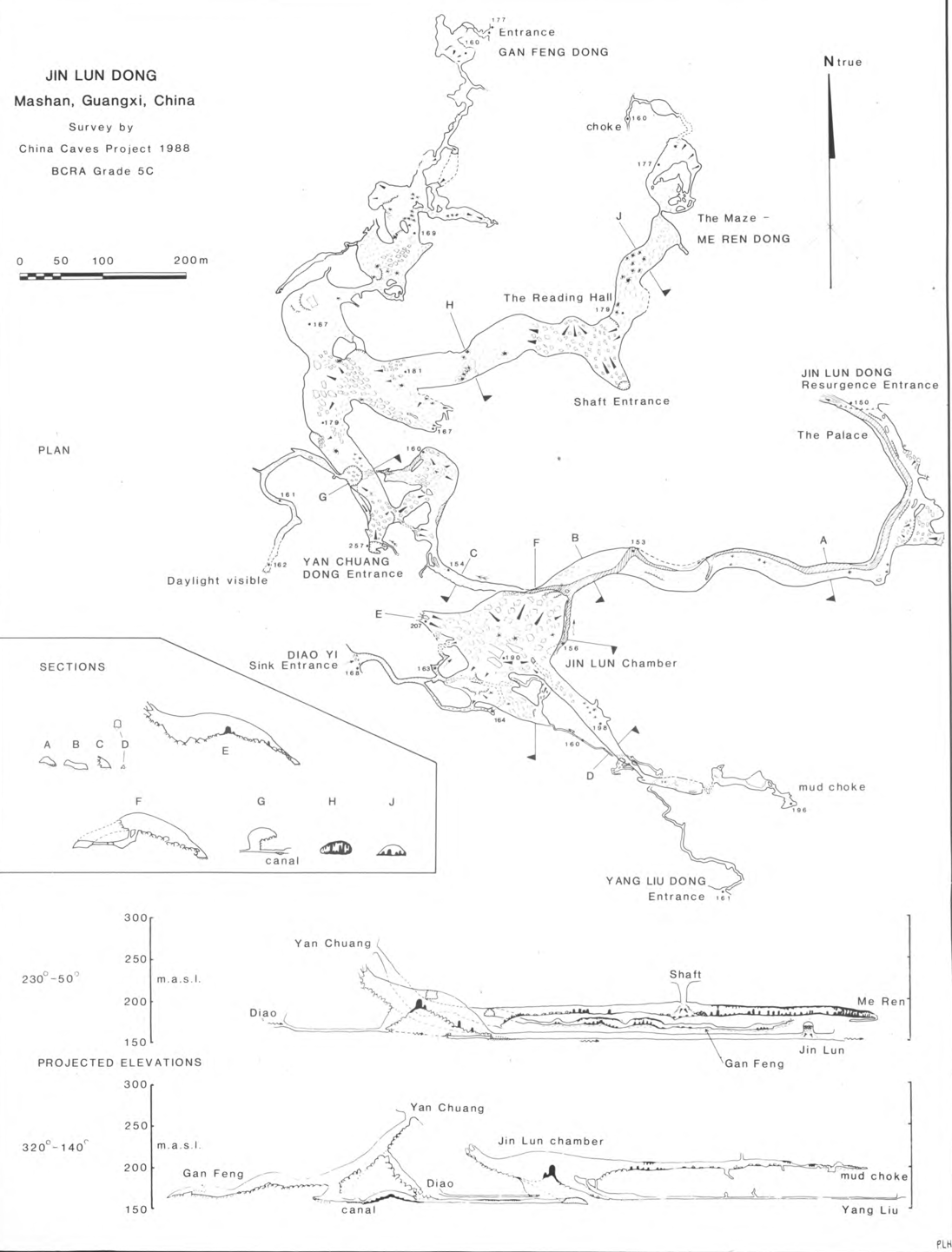
JIN LUN DONG
Jin Lun Dong (Figure I) is a cave well known to the people of Mashan County. The complex 7km of passage lies in a block of limestone 20km south of the county town, bounded to the west by loess hills and to the east by a 2km wide valley cutting through the 'fencong' karst (Figure 2). The most well known entrance is the resurgence close to the main NanninglMashan road but this is one of seven entrances to the system. The river sinks at Diao Yi, as it leaves the non-karst hills, into a large boulder collapse. Entrance to the active river passage can be gained over the boulder pile. The passage soon becomes low, muddy and wide after 100m is impassable as the water flows under the massive collapse of the main chamber. Re-emerging from the choke on the east wall of the chamber the flow goes north to a junction which bounds the northern corner of this 200m by 200m by 50m high natural void. The river then flows down the main passage, past gravel banks and massive speleothems to the Palace and the resurgence. This river-way and the Jin Lun chamber are adorned with electric cables and finish with steps and bamboo bridges for the tourists entering the 'show cave'.
In a chamber above the river just beyond the risings' twilight zone, concrete blocks have been set in rows to provide seating for an underground cinema. The ticket office is situated at the altar to the cave god at this entrance. The altar is adorned with long red inscribed banners and surrounded with fresh remains of burnt incense. The tourist path leads through and up the Main Chamber slope to a high, well-decorated passage which is choked totally with flowstone and mud after 500m. A small vadose canyon passage runs below this to a squeeze entrance a kilometre south-east, Yang Liu Dong. This and the other passages at this level appear to take wet season flood water from the karst boundary valley to join the main river.
As with many caves in. the tower karst, Jin Lun has been used by local people as an easy underground route between valleys. However, the Jin Lun through trip is more daunting than most, requiring a climb up steep ground to the large fossil entrance of Yan Chuang Dong almost 100m above the river sink. From here the through trip goes east following a very loose descent away from the obvious high passage and losing the full 100m just gained on the surface. A stooping passage then leads to the northern bottom corner of the Main Chamber and so by the tourist trail out to the resurgence and the village in the next valley.
The huge fossil passage running north from Yan Chuang Dong has two major branches: one leads to the Gang Feng Dong entrance and the other past the Shaft Entrance to Me Ren Dong, The Maze. Still in daylight from the Yan Chuang Dong entrance a descent of the scree and boulder slope of the main passage leads to a collapse pit 30m across occupying half the passage width. It was into the bottom of this that one survey team emerged from a boulder choke at the same moment as another team chose a station on the pit lip above to survey the SOm wide high level passage. Good news for survey closures! The pit bottom team had come along small and sometimes swimming passages from the Jin Lun main chamber. The team at the top were heading into the cave when after 300m they came to a chamber at the branch junction where there was much evidence of nitrate extraction. This resource was probably used by people from both valleys as a well worn route weaves from here through a highly decorated, in fact almost choked, passage to Gang Feng Dong. Exploration in this area, up a tortuous series of body-sized phreatic tubes followed by an airy climb down flowstone took us into a remote hall where charcoal on ledges told us we were not the first. Maybe the 'cavers' before us were searching for Jin Lun, the local lad who was lost for three days in the cave 900 years ago and gave his name to it. The other branch from the nitrate digs contains colossal passage with many fine stalagmites, the shaft entrance at the Reading Hall and large areas of gour floor with almost complete cave pearl cover. The Maze at the end of this passage is another flowstone choke through which there are numerous routes and round trips but no obvious continuation. Relating the cave survey to the surface topography shows the Maze to lie in a tower protruding from the main mass with little chance of further cave development in this direction.
In many areas of the cave there has been major speleothem collapse which could relate to an earthquake recorded in Nanning in the 17th century.
The Jin Lun River, having left the cave, soon joins a sluggish (dry season) flow south. Another tributary to this valley comes from the Gang Zei caves.
[Tim Fogg]
FOGG, Tim (1990) : Jin Lun Dong and the caves of Gang Zei, Mashan County, Guangxi.-
Cave Science vol. 17 nr. 2 : 67-70.
Analyse : BBS
In the Fengcong - karst area of SE Mashan Co. a total of 15 km of cave passages was surveyed. Jin Lun Dong is a multiple level system with an active streamway, totalizing 7 km. The six caves forming the Gang Zei River cave system totalize 7 km of active and fossil passages. (3 cave maps, speleol. area map, phot. (RB)
4764 caractères - Lu 204 Fois
Bibliographie 4
FOGG, Tim (1990) : Jin Lun Dong and the caves of Gang Zei, Mashan County, Guangxi.-
Cave Science vol. 17 nr. 2 : 67-70.
In the Fengcong - karst area of SE Mashan Co. a total of 15 km of cave passages was surveyed. Jin Lun Dong is a multiple level system with an active streamway, totalizing 7 km. The six caves forming the Gang Zei River cave system totalize 7 km of active and fossil passages. (3 cave maps, speleol. area map, phot. (RB)
Source : BBS
ZHANG, Shouyue (1993): Grand caves of China.-
Proceedings XI Intern. Congress of Speleology, 2nd-8th August 1993, Beijing 1993: 236-237 (3 tab.) (chines. summ.).
Lists 21 caves with more than 200 m in elevation (Zhaidong -552 m; Gebihe -445 m, Wuajidong -430 m etc.); and 19 caves with more than 4,8 km in length (Tenglongdong 33,52 km; Duobingdong 17,2 km; Baimodong 13,7 km etc.). (RB).
Source : BBS
JIAN, Chen (1990) : Caves in China.-
NSS News vol. 48(2) : 43.
A list of 29 caves more than 2 km long.Tenglong dong (Hubei) 32, 0 km; Baishui gond(Guizhou) 22, 45 km; Duobing dong (Guizhou) 17, 21 km; Baimo dong (Guangxi) 15, 70 km etc. (RB)
Source : BBS
AA China Caves Project 1987-1988 (1989?)
Published by China Caves Project Edited by P & T Fogg
Rapport d’expédition spéléologique anglaise 1987-1988 dans le Guizhou et le Guangxi. 32 pp, 36 photos couleurs, 2 topographies.
Source :
Images 0
Topographie 1
Source : Ccp
Expédition 1
Cette grotte a été identifiée ou explorée au minimum par cette (ces) expédition (s) :
Recherche