
Grottes et karsts de Chine
Sur les traces de Xu Xiake
Grottes
 Houdong 后洞
Détail24/03/2025 9:14
Autres noms : Cave behind
Province, Préfecture, District :
Guangxi 广西壮族自治区, Hechi 河池市, Bama 巴马瑶族自治县
Latitude Nord - Longitude Est :
24.332896 - 107.095200
Altitude (m) : 0
Développement (m) : 3 472
Profondeur (m) :
Profondeur - / + (m) : 0 /
Carte
Description 1
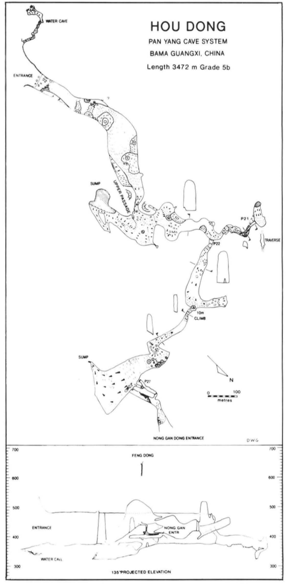
Hou Dong
Hou Dong ("the cave behind") is a continuation of the main passage of Qian Dong and entered through a ravine revealing the former extent of the cave now being truncated by solutional lowering and spalling of rock from the 100m cliff immediately above the entrance (Figure 8). At the mouth of this ravine is a small cave which leads east and then south before emerging at an entrance into the main valley/doline. The locals said that this was their source of water during the wet part of the year. At the bottom of the slope down from the entrance was a dried up pool and beyond a fine collection of water-rounded limestone boulders not seen anywhere else in the caves - up to 80cm diameter and clearly indicating periodic flooding by very fast flowing water.
The mouth of Hou Dong is impressive by any standards and enlarges dramatically inwards. After negotiating boulders and speleothems, a drop leads onto a beautiful sandy floor, the roof rises and a 78m high stalagmite pillar is passed on the right into a square-roofed, walled and floored gallery over 90m broad. Ahead is a stalagmite perched like a dead lighthouse on top of a boulder pile, rising from 70m above the floor. Skirting to the right of this slope is seen developing out of the right wall and curving round into the blackness ahead. This was climbed and then traversed into a passage immediately above the main one below. This upper, fossil passage ends abruptly at a balcony overlooking the 'main way on' further into the cave.
The lower passage changes its character at this point. The sand floor rises to a slight peak (indicating tremendous flood-flow regime towards the entrance) followed by a long downwards slope which is well gullied, past massive stalagmites, to a vertical drop. Facing down the drop is a long slope at 3So leading up to the left and a vertical wall up a short slope to the right. The drop can be by-passed by climbing up the slope to the left, traversing forwards and then descending. This leads to a point, 30m below, in a gully leading to lake. The water level obviously rises by at least 50m in flood but in the low-water conditions in which the exploration was carried out no significant flow was detectable.
In general these caves are developed in massive limestones folded on a N-S axis with local dips of 30° to 40°. The lake passage described above is developed in beds dipping at 35° to the south. Traversing the mud-covered bedding plane floor which slides straight down into the lake leads to a vertical wall which prevents further progress. The far side of the lake appeared to be without exit, although the draught indicated a way out up in the roof. Climbing up the bedding led into a higher tube, with two connections down-dip to the lake area. Continuing along the tube led back into the slope which was descended to reach the lake. At the top of this slope, a level platform abutting solid wall can be followed to a low 4m opening into the main passage continuation, where the roof suddenly rises to a great height and the overhead balcony at the end of the fossil passage from the entrance series is clearly visible. Level mud floor stretches ahead with cracks up to 5cm wide infilled with more recent mud. To the left is a large alcove with a >50m high stalagmite bounding its right side. (This may have afforded a connection through into the entrance series in the past). To the right a slope leads up to an area above flood level, containing scraped out sleeping areas and remnants of bamboo.
The large passage continues easily, with its solid mud floor, flanked by massive stalagmite columns. A high level passage guarded by a calcited fill overhang is passed on the right. Below and beyond, the character of the cave changes abruptly. Gone is the mud and after some very beautiful orange coloured gour- pools the rock becomes clean and corroded into blocks which, pitted and spiked, make for miserable progress. Passing two small pits, a rift in the floor leads down to a blind 20m pitch, above which a traverse leads across calcited mud to reach the top of a ramp. Height is quickly lost in descending this and a sump pool terminates exploration.
The lower passage just described is clearly active in wet periods but no way on was found to the low-level active and possibly phreatic passages which underlie the system. Retracting the path to the big upper passage guarded by a stalagmite overhang is the key to the northward continuation of the cave. The overhang was climbed up friable material to an exposed climb and traverse up and across a smooth calcited mud slope. There was no evidence of previous ascents but the story gleaned from the village at the entrance to the cave - that many years ago men had been right through the mountain to an exit on the far side - corroborated when, along the passage above the climb, bundled sticks and the remains of bamboo torches were discovered. In this totally fossil gallery speleothems are abundant with a remarkable quantity of cave pearls scattered over the floor. The gallery bifurcates: left ascends flowstone and boulders to a dead end, while right climbs between stalagmites to a higher level where passage heights were estimated at over 150m. A switch-back floor ends after a final climb at a large level area, with a steep ramp dropping down in front.
In this cave we again made some interesting meteorological observations. A steady draught of 2m s blew up the passage, across the level area and down the ramp to a height of 1.5m above the floor. Above this, the air was much warmer and tranquil.
Outside temperatures varied from S to 15°C considerably cooler than the 21-22°C mean, accounting for these streams of colder air flowing below static air at mean cave temperature above. The same phenomenon was responsible for the clouds in Bai-Mo Dong.
The ramp proved to be every bit as impressive as the view from the top. Its calcited floor slopes downwards, steepening and becoming muddier, to its final end in a sumped, muddy canal, 140m below the height of the platform . The large air-mass moving at the upper level is entirely lost by this time but must exit high in the unseen walls or roof.
The exit from the platform at the top of the ramp is unlikely and unexpected. An alcove on the north side of the passage leads to a small dry shaft with a powerful upward draught. Here a porcelain spoon was found along with rotted stempIes at the bottom of the 28m shaft, proving that the villagers' story was right. The base of the shaft leads into a bigger passage and a 10m climb, into a lower cave level, Nong Gan Dong (Figure 8). To the north this quickly comes to an exit at the bottom of a deep and impressive doline, ringed on three sides by vertical cliffs at least 250m high and jungle-covered boulder slopes. Turning into the cave, it ends after 200m at a flowstone blockage, probably connected with the ramp in the major cave above.The exit doline is by far the most impressive surface feature discovered in the Bama area, being so deep and precipitous that the map-makers, presumably working from air-photos, have completely misinterpreted it. The path leads upwards and soon passes an inconspicuous 2 x 3m entrance to an inclined blowing shaft: Feng Dong.
GILL, Dave; LYON, Ben; FOWLER, Simon (1990) : The caves of Bama County, Guangxi, China.-
Cave Science vol. 17 nr. 2 : 55-66.
Analyse : BBS
Bama County contains a large hydrological system with associated caves, draining into the Pan Yang River, a tributary to the Hongshui. The Pan Yang cave system between Beimo Dong (main sink) and Fulong Dong rising was surveyed over 16 km, with passages as high as 145 m and 80 m in diameter. A total of 16 caves and 17 km of passages in Bama Co. were surveyed (10 cave surveys, area map, speleol.map, phot.). (RB)
7262 caractères - Lu 288 Fois
Bibliographie 2
GILL, Dave; LYON, Ben; FOWLER, Simon (1990) : The caves of Bama County, Guangxi, China.-
Cave Science vol. 17 nr. 2 : 55-66.
Bama County contains a large hydrological system with associated caves, draining into the Pan Yang River, a tributary to the Hongshui. The Pan Yang cave system between Beimo Dong (main sink) and Fulong Dong rising was surveyed over 16 km, with passages as high as 145 m and 80 m in diameter. A total of 16 caves and 17 km of passages in Bama Co. were surveyed (10 cave surveys, area map, speleol.map, phot.). (RB)
Source : BBS
WALTHAM, A.C; WILLIS, R.G. (eds.) (1993): Xingwen. China Caves Project 1989-1992.-
Bridgwater TA7 0LG, British Cave Research Association. 48pp. (maps, photos, surveys) (chinese abstract). ISBN 0-900265-15-9.
A report on various projects: The Pan Yang Caves, Bama, Guangxi Province 1989. The Mengzi karst of southern Yunnan 1991. The karst of the Tibet Plateau 1992 and the largest part, the exploration of the Xingwen karst of Sichuan Province 1992. Geomorphol. map of Karst of Xingwen, Sichuan. Cave surveys of : Zhucaojing (Xingwen, Sichuan): 8,80 km +1,75 km; Tiencuan dong (Xingwen, Sichuan): 8,10 km /-208 m; Xia Dong (Xingwen, Sichuan): 2,20 km; Yanzi Luo Shui Dong (Xingwen, Sichuan): 1,80 km /- 316 m + 1,12 km / -199 m; Pan Yang Dong cave system (Bama Guangxi). (RM).
Source : BBS
-- Images 0
Topographie 1
Source : Ccp
Expédition 1
Cette grotte a été identifiée ou explorée au minimum par cette (ces) expédition (s) :
Recherche