Grottes et karsts de Chine
Sur les traces de Xu Xiake
 Luojiabaodong - 洞
Détail26/03/2025 12:56:18
Province, Préfecture, District :
Guangxi 广西壮族自治区, Hechi 河池市, Bama 巴马瑶族自治县
Latitude Nord - Longitude Est :
24.335529 - 107.083208
Altitude (m) : 0
Développement (m) : 1 060
Profondeur (m) :
Profondeur - / + (m) : 0 /
Volume (m3) :
Carte
Description 1
Luo Jia Bao Dong
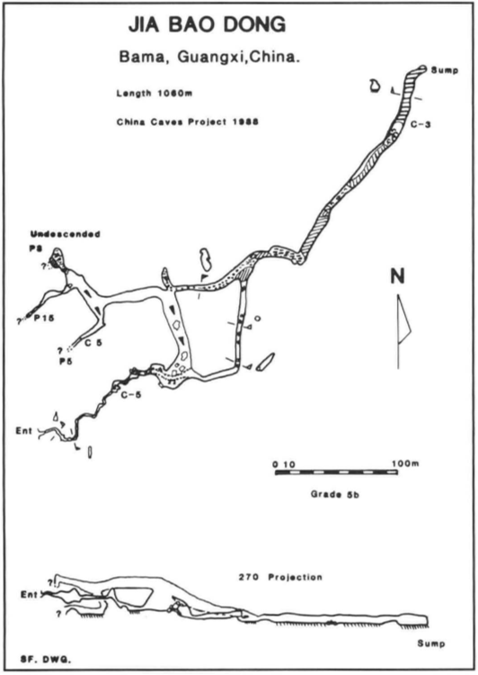
In contrast to the surrounding caves, Luo Jia Bao Dong, (Figure 7) has an entrance smaller than most on Mendip. The dry streambed that enters Limo Dong is fed by a stream flowing from the shales to the west but also from a resurgence on the north side of the valley. Crafty poking around in boulders on the steep side of the streambed just prior to the resurgence reveals a small winding phreatic passage. 100m later it drops down a climb to a small deep pool that deterred previous Chinese visitors. Careful but somewhat extreme stretching avoids a wetting, but more pools follow. A boulder chamber is passed and the passage continues small but nicely sculptured. Just before the final long canal section, a passage leads off to the left. This ascends a ramp to a junction with several passages. One is blind, one enters a blind chamber and the last passage 'goes' but with a sense of deja vu as you enter the boulder chamber from above. Nevertheless, the high level continues to a complex area of sumps, undescended pitches to pools and mud. Flood debris adds to the impression reinforced by the survey, that you are close to the surface. A troglobitic carabid beetle was captured here together with a rich cave fauna _ a good site for any future collecting.
GILL, Dave; LYON, Ben; FOWLER, Simon (1990) : The caves of Bama County, Guangxi, China.-
Cave Science vol. 17 nr. 2 : 55-66.
Analyse : BBS
Bama County contains a large hydrological system with associated caves, draining into the Pan Yang River, a tributary to the Hongshui. The Pan Yang cave system between Beimo Dong (main sink) and Fulong Dong rising was surveyed over 16 km, with passages as high as 145 m and 80 m in diameter. A total of 16 caves and 17 km of passages in Bama Co. were surveyed (10 cave surveys, area map, speleol.map, phot.). (RB)
1277 caractères - Lu 130 Fois
Bibliographie 1
GILL, Dave; LYON, Ben; FOWLER, Simon (1990) : The caves of Bama County, Guangxi, China.-
Cave Science vol. 17 nr. 2 : 55-66.
Bama County contains a large hydrological system with associated caves, draining into the Pan Yang River, a tributary to the Hongshui. The Pan Yang cave system between Beimo Dong (main sink) and Fulong Dong rising was surveyed over 16 km, with passages as high as 145 m and 80 m in diameter. A total of 16 caves and 17 km of passages in Bama Co. were surveyed (10 cave surveys, area map, speleol.map, phot.). (RB)
Source : BBS
Images 0
Topographie 1

Source : Ccp
Expédition 1
Cette grotte a été identifiée ou explorée au minimum par cette (ces) expédition (s) :
Recherche