
Grottes et karsts de Chine
Sur les traces de Xu Xiake
Grottes
 Tianpindong 田平洞
Détail25/03/2025 10:29:28
Autres noms : Grotte de Tianpin
Province, Préfecture, District :
Guangxi 广西壮族自治区, Hechi 河池市, Bama 巴马瑶族自治县
Latitude Nord - Longitude Est :
24.356908 - 107.079936
Altitude (m) : 0
Développement (m) : 506
Profondeur (m) :
Profondeur - / + (m) : 70 /
Carte
Description 1
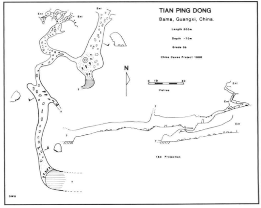
Tian Ping Dong
Situated 6km north of Bai-Mo, 2km east of the main road, this cave is a wet weather stream sink, the water draining from the shales to the west. A 15m diameter entrance was explored to a muddy lake which was not investigated further (Figure II).
A high level fossil route can be followed high above the main entrance and this joins into the roof of the main passage. The passage terminates at a steep 15m muddy slope to a lake which again was not investigated.
GILL, Dave; LYON, Ben; FOWLER, Simon (1990) : The caves of Bama County, Guangxi, China.-
Cave Science vol. 17 nr. 2 : 55-66.
Analyse : BBS
Bama County contains a large hydrological system with associated caves, draining into the Pan Yang River, a tributary to the Hongshui. The Pan Yang cave system between Beimo Dong (main sink) and Fulong Dong rising was surveyed over 16 km, with passages as high as 145 m and 80 m in diameter. A total of 16 caves and 17 km of passages in Bama Co. were surveyed (10 cave surveys, area map, speleol.map, phot.). (RB)
475 caractères - Lu 246 Fois
Bibliographie 2
GILL, Dave; LYON, Ben; FOWLER, Simon (1990) : The caves of Bama County, Guangxi, China.-
Cave Science vol. 17 nr. 2 : 55-66.
Bama County contains a large hydrological system with associated caves, draining into the Pan Yang River, a tributary to the Hongshui. The Pan Yang cave system between Beimo Dong (main sink) and Fulong Dong rising was surveyed over 16 km, with passages as high as 145 m and 80 m in diameter. A total of 16 caves and 17 km of passages in Bama Co. were surveyed (10 cave surveys, area map, speleol.map, phot.). (RB)
Source : BBS
WALTHAM, A.C; WILLIS, R.G. (eds.) (1993): Xingwen. China Caves Project 1989-1992.-
Bridgwater TA7 0LG, British Cave Research Association. 48pp. (maps, photos, surveys) (chinese abstract). ISBN 0-900265-15-9.
A report on various projects: The Pan Yang Caves, Bama, Guangxi Province 1989. The Mengzi karst of southern Yunnan 1991. The karst of the Tibet Plateau 1992 and the largest part, the exploration of the Xingwen karst of Sichuan Province 1992. Geomorphol. map of Karst of Xingwen, Sichuan. Cave surveys of : Zhucaojing (Xingwen, Sichuan): 8,80 km +1,75 km; Tiencuan dong (Xingwen, Sichuan): 8,10 km /-208 m; Xia Dong (Xingwen, Sichuan): 2,20 km; Yanzi Luo Shui Dong (Xingwen, Sichuan): 1,80 km /- 316 m + 1,12 km / -199 m; Pan Yang Dong cave system (Bama Guangxi). (RM).
Source : BBS
-- Images 0
Topographie 1
Source : Ccp
Expédition 1
Cette grotte a été identifiée ou explorée au minimum par cette (ces) expédition (s) :
Recherche