
Grottes et karsts de Chine
Sur les traces de Xu Xiake
 Baladong - 巴拉洞
Détail26/03/2025 10:53:02
Province, Préfecture, District :
Guangxi 广西壮族自治区, Hechi 河池市, Bama 巴马瑶族自治县
Latitude Nord - Longitude Est :
24.345323 - 107.085112
Altitude (m) : 0
Développement (m) : 904
Profondeur (m) : 60
Profondeur - / + (m) : 60 /
Volume (m3) :
Carte
Description 1
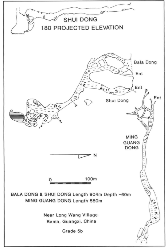
Shui and Bala Dong
Just beyond Liao Ping Dong is a closed depression where three entrances unite at a 15m diameter phreatic tube (Figure 10). A couple of free-climbable drops lead to a decorated chamber with a steep slope down to the left which terminates at the edge of a 26m pitch. This pitch can be overlooked by climbing from the chamber up to a 20m rocky pinnacle.
At the bottom of the 26m pitch a muddy slope leads to the final lake with no way on at the far side.
GILL, Dave; LYON, Ben; FOWLER, Simon (1990) : The caves of Bama County, Guangxi, China.-
Cave Science vol. 17 nr. 2 : 55-66.
Analyse : BBS
Bama County contains a large hydrological system with associated caves, draining into the Pan Yang River, a tributary to the Hongshui. The Pan Yang cave system between Beimo Dong (main sink) and Fulong Dong rising was surveyed over 16 km, with passages as high as 145 m and 80 m in diameter. A total of 16 caves and 17 km of passages in Bama Co. were surveyed (10 cave surveys, area map, speleol.map, phot.). (RB)
470 caractères - Lu 124 Fois
Bibliographie 2
GILL, Dave; LYON, Ben; FOWLER, Simon (1990) : The caves of Bama County, Guangxi, China.-
Cave Science vol. 17 nr. 2 : 55-66.
Bama County contains a large hydrological system with associated caves, draining into the Pan Yang River, a tributary to the Hongshui. The Pan Yang cave system between Beimo Dong (main sink) and Fulong Dong rising was surveyed over 16 km, with passages as high as 145 m and 80 m in diameter. A total of 16 caves and 17 km of passages in Bama Co. were surveyed (10 cave surveys, area map, speleol.map, phot.). (RB)
Source : BBS
WALTHAM, A.C; WILLIS, R.G. (eds.) (1993): Xingwen. China Caves Project 1989-1992.-
Bridgwater TA7 0LG, British Cave Research Association. 48pp. (maps, photos, surveys) (chinese abstract). ISBN 0-900265-15-9.
A report on various projects: The Pan Yang Caves, Bama, Guangxi Province 1989. The Mengzi karst of southern Yunnan 1991. The karst of the Tibet Plateau 1992 and the largest part, the exploration of the Xingwen karst of Sichuan Province 1992. Geomorphol. map of Karst of Xingwen, Sichuan. Cave surveys of : Zhucaojing (Xingwen, Sichuan): 8,80 km +1,75 km; Tiencuan dong (Xingwen, Sichuan): 8,10 km /-208 m; Xia Dong (Xingwen, Sichuan): 2,20 km; Yanzi Luo Shui Dong (Xingwen, Sichuan): 1,80 km /- 316 m + 1,12 km / -199 m; Pan Yang Dong cave system (Bama Guangxi). (RM).
Source : BBS
Images 0
Topographie 1
Source : Ccp
Expédition 1
Cette grotte a été identifiée ou explorée au minimum par cette (ces) expédition (s) :
Recherche