
Grottes et karsts de Chine
Sur les traces de Xu Xiake
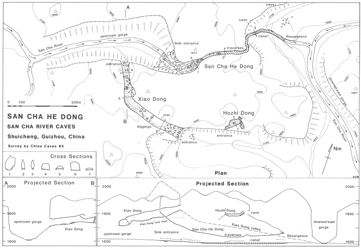
 Sanchahedong - 三岔河洞
Détail13/03/2025 18:32:23
Autres noms : Grotte De La Riviere Sancha, Luoshuidong
Province, Préfecture, District :
Guizhou 贵州省, Liupanshui Shi 六盘水市, Shuicheng 水城
Latitude Nord - Longitude Est :
26.638230 - 104.953822
Altitude (m) : 0
Développement (m) : 1 120
Profondeur (m) :
Profondeur - / + (m) : 0 /
Volume (m3) :
Carte
Description 0
Bibliographie 2
ZHANG, Yingjun; YANG, Mingde; HE, Caihua (1992): Karst geomorphology and environmental implications in Guizhou, China.-
Cave Science vol. 19 No.1: 13-20 (10 fig., 1 tab., 8 phot.).
The vertical karst development caused by the lowering of groundwater table shows itself in the multi- level cave systems which exist in both the plateau and the gorge areas. The problems of pollution, surface collapse and engineering works are related to the karst geomorphological environment. The benefits and defects of the dams sited in the gorges are discussed. (RB)
Source : BBS
WALTHAM, A.C. (editor) (1986) : China caves’85.
Publ. The Royal Geogr. Soc. London 1986: 60pp.,phot., surveys area maps.
An account of the first anglo-chinese project in the caves of south China is given. Short description ,of karst geology and landforms in Guangxi (with tower karst: peak clusters and peak forests) and in Guizhou (with conical karst hills). Short description and surveys of numerous cavesexplored : the guanyan cave systems totalizing 11,4 km/-75; the Shibangiao Dong with 1,8 km; the Xizheu Yan with 3 km; the Maliu Kang with 2,5 km etc. Notes about working, living, travelling in China
Source : BBS
Images 0
Topographie 1
Source : Ccp
Expédition 1
Cette grotte a été identifiée ou explorée au minimum par cette (ces) expédition (s) :
Recherche