
Grottes et karsts de Chine
Sur les traces de Xu Xiake
 Longtandong - 龙潭洞
Détail15/03/2025 14:37:57
Province, Préfecture, District :
Guizhou 贵州省, Guiyang Shi 贵阳市, Qingzhen 清镇
Latitude Nord - Longitude Est :
-
Altitude (m) : 0
Développement (m) : 285
Profondeur (m) : 285
Profondeur - / + (m) : 285 /
Volume (m3) :
Carte
Description 0
Bibliographie 2
WALTHAM, A.C. (editor) (1986) : China caves’85.
Publ. The Royal Geogr. Soc. London 1986: 60pp.,phot., surveys area maps.
An account of the first anglo-chinese project in the caves of south China is given. Short description ,of karst geology and landforms in Guangxi (with tower karst: peak clusters and peak forests) and in Guizhou (with conical karst hills). Short description and surveys of numerous cavesexplored : the guanyan cave systems totalizing 11,4 km/-75; the Shibangiao Dong with 1,8 km; the Xizheu Yan with 3 km; the Maliu Kang with 2,5 km etc. Notes about working, living, travelling in China
Source : BBS
ZHANG, Shouyue (1993): Grand caves of China.-
Proceedings XI Intern. Congress of Speleology, 2nd-8th August 1993, Beijing 1993: 236-237 (3 tab.) (chines. summ.).
Lists 21 caves with more than 200 m in elevation (Zhaidong -552 m; Gebihe -445 m, Wuajidong -430 m etc.); and 19 caves with more than 4,8 km in length (Tenglongdong 33,52 km; Duobingdong 17,2 km; Baimodong 13,7 km etc.). (RB).
Source : BBS
Images 0
Topographie 1
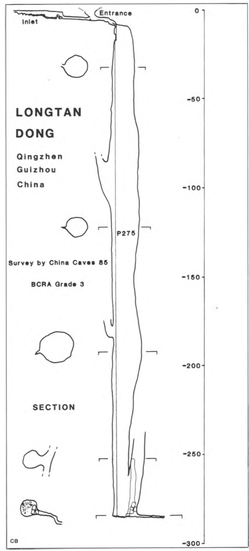
Source : Ccp
Expédition 1
Cette grotte a été identifiée ou explorée au minimum par cette (ces) expédition (s) :
Recherche