
Grottes et karsts de Chine
Sur les traces de Xu Xiake
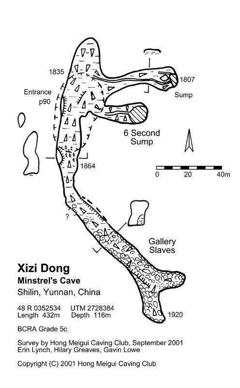
 Xizidong - 洞
Détail
Autres noms : Minstrel's Cave
Province, Préfecture, District :
Yunnan 云南省, Kunming 昆明, Shilin (Lu'nan) 石林彝族自治县
Latitude Nord - Longitude Est :
24.66271 - 103.54269
Altitude (m) : 1925
Développement (m) : 432
Profondeur (m) : 217
Profondeur - / + (m) : 0 /
Volume (m3) :
Carte
Description 1
Near Hai Yi village, Shilin
Xizi's alluringly over-hung entrance is visible from camp, but deceptively hard to find closer up. The pitch head is reached by a scramble down through bushes to a traverse down and to the right over piles of dead vegetation. A sizeable stump provides the belay for the first short drop onto a large ledge. A scramble up and to the left gains another tree-belay, this time over a proper Chinese-style drop, complete with rope protectors and a constant shower of debris. After 16 metres an overhang and 2 bolts are reached. From here the loose rocks fall a further 50 metres to a soft mud floor.
From the base of the shaft, facing South, away from the descent route, behind (North) a mud slope goes up to a wide alcove with no way on. Down and to the left a soggy channel in the mud is followed to low mud-filled passage ending in a sump. Up and to the left a crest in the mud is reached from which it is possible to descend to a second passage. Here twin steep mud banks flank a channel of very wet mud leading to 6 Second Sump, where the passage bells out and the ceiling rises in an arch that returns a six-second echo.
Back at the pitch, the main way on lies straight ahead, up the steep mud slope. Ascent is possible by kicking mud steps along the right-hand wall. Past a thin cover of vegetation at the top, the gloopy wet mud is thankfully left behind. To the right, a high window looks back into the daylight shaft, while ahead the Gallery Slaves Passage slopes up with an increasing density of fossil formations. Scrambling past a large ice cream cone flowstone mound, the passage descends briefly before encountering a calcite cliff on the right. The passage forks, with a short branch going off to the left to a calcite-coated end, while to the right a climb up along the left-hand wall gains the top of the calcite cliff and the final 20 metres of the cave.
Hilary Greaves
Erin Lynch
Gavin Lowe
http://www.hongmeigui.net/
http://www.hongmeigui.net/
Analyse : Web
Site sur les campagne d’expéditions du club de Hong Mei Gui. Dans les provinces du Guizhou, Guangxi, Yunnan. Explorations dans les comtés de Leye, Nandan, Guilin. Données chiffrées sur les cavités topo données topo et photo chronique d’expédition.
1940 caractères - Lu 144 Fois
Bibliographie 1
http://www.hongmeigui.net/
http://www.hongmeigui.net/
Site sur les campagne d’expéditions du club de Hong Mei Gui. Dans les provinces du Guizhou, Guangxi, Yunnan. Explorations dans les comtés de Leye, Nandan, Guilin. Données chiffrées sur les cavités topo données topo et photo chronique d’expédition.
Source : Web
Images 0
Topographie 1
Source : Hmg
Expédition 1
Cette grotte a été identifiée ou explorée au minimum par cette (ces) expédition (s) :
Recherche