
Grottes et karsts de Chine
Sur les traces de Xu Xiake
 Monks Cave -
Détail
Province, Préfecture, District :
Chongqing 重庆, , Wulong 武隆县
Latitude Nord - Longitude Est :
-
Altitude (m) : 0
Développement (m) : 0
Profondeur (m) :
Profondeur - / + (m) : 0 /
Volume (m3) :
Carte
Description 1
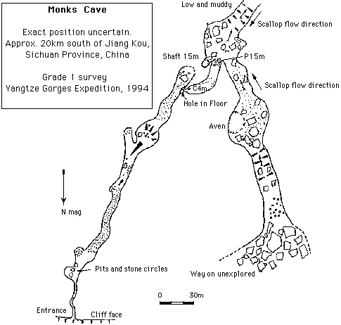
Exact Position unknown. Approximately 20km South of Jiang Kou. From the town of Jiang Kou a track winds south along the Furong river. After 30 minutes it leaves the river but continues south passing through a number of small settlements. After 45 minutes the track quality decreases and climbs steeply towards a 500 metre high cliff face. Monks cave lies in trees and shrubs beneath this cliff. The view from Monks Cave is spectacular with a 20 mile panoramic view towards Jiang Kou.
The entrance to Monks cave is in a low 5 metre wide, 3 metre high arch and initial progress is made by crawling along a 1.5 metre diameter phreatic tube. The cold outward draught is at its strongest in this section. Approximately 50 metres of crawling and stooping ends when a 10 metre square passage is entered and continues from here onwards. On entering this passage there are a number of pits and stone walled circles sunk into the sand floor.
YGE94 p80(S)
Easy going along sandy floored passage follows a well worn path passing through some larger chambers and over sediment banks for 300 metres. The passage from this chamber is littered with the smashed remains of stalagmites.
After 500 metres a small hole in the floor emits a powerful draught and provides entrance to a lower section of cave. Climbing down the hole a short but very awkward climb gains a 50 metre section of once decorated passage ending at a short climb down between boulders and a 15 metre shaft.
At the base of the shaft is a boulder and sediment floored 30 metre square chamber with a small misfit stream. A small waterfall on the west of the chamber leaves the chamber in a large passage trending south. The stream flows between huge banks of mud, filling much of what would have been a 10 metre square trunk passage. Eventually after 100 metres the way on becomes low.
Returning to the chamber a passage to the north enters through a climb over boulders. Easy going for 300 metres over sand floors and fallen blocks leads past numerous formations and high avens to a flat roofed 3 metre high section. Much of this is filled with columns and brilliant white gour flows. Progress is made for 30 metres through the columns to a boulder choke. There appears no way over the top but on the west side a passage can be followed via alternate crawling and standing which was not pushed to a conclusion.
Analyse :
2363 caractères - Lu 122 Fois
Bibliographie 1
http://www.brianjudd.pwp.blueyonder.co.uk/china:china96/jaingkou/wulong3/wulong3.html#top
Site sur les projets China-Caves et notamment les expé Yangtze Gorges expeditions 94 et 96 et les perspectives. Topos, photos, cartes, descriptifs, anecdotes...
Source : Web
Images 0
Topographie 1
Source : Ccp
Expédition 1
Cette grotte a été identifiée ou explorée au minimum par cette (ces) expédition (s) :
Recherche