
Grottes et karsts de Chine
Sur les traces de Xu Xiake
 Daodong -
Détail
Autres noms : Resurgence cave
Province, Préfecture, District :
Guizhou 贵州省, Qianxinan 黔西南布依族苗族自治州, Anlong 安龙
Latitude Nord - Longitude Est :
25.301841 - 105.622254
Altitude (m) : 0
Développement (m) : 1 524
Profondeur (m) :
Profondeur - / + (m) : 0 /
Volume (m3) :
Carte
Description 1
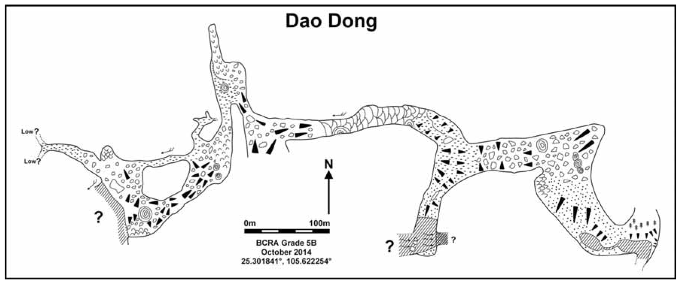
Dao Dong- ‘Resurgence Cave’- 25.301841°, 105.622254°
The Resurgence Cave is located ~2km west of the main area resurgence. There are two entrances immediately adjacent to each other, one heads north and the other to the east.
The initial reccee of these two entrances identified the eastern entrance as leading to an underground river and the north trending cave as concluding after less than 100m. When the team returned to survey and further explore the caves, a large continuation of the northerly entrance was found heading in a westerly direction. This was initially missed as it was disguised behind a 30m high stalagmite!
600m of cave was surveyed in the northern entrance to a point overlooking a deep body of water with a strong draught blowing over it. The pitch down to the water was not descended nor the lake explored due to lack of time, it was the last day of the expedition.
The eastern entrance was followed to a junction. South of the junction the large underground river was accessed which runs from west to east. At the easterly most point the river sumps under a solid wall. An inflatable boat was used to attempt a look upstream but the current proved difficult to negotiate and the attempt was abandoned. The upstream continuation of this large river remains unexplored.
Back at the junction the cave continues to the east in giant proportions until it ends in the bottom of a doline. The sandy beach and lake surrounded by heavy vegetation in the bottom of the doline made for a very atmospheric spot. This can be accessed form the surface via a series of small tracks and is easily accessible to local people.
Aut. Var.The Guilin Institute of Karst Geology In association with the China Caves Project (2014)
The China Caves Project Expedition Report 2014. Report to the Anlong People’s Government
Analyse :
Rapport d’expédition dans le district de Anlong (Guizhou). 69 pages, 3 cartes, 28 photos couleurs, 12 topographies.
1641 caractères - Lu 134 Fois
Bibliographie 1
Aut. Var.The Guilin Institute of Karst Geology In association with the China Caves Project (2014)
The China Caves Project Expedition Report 2014. Report to the Anlong People’s Government
Rapport d’expédition dans le district de Anlong (Guizhou). 69 pages, 3 cartes, 28 photos couleurs, 12 topographies.
Source :
Images 0
Topographie 1
Source : Ccp
Expédition 1
Cette grotte a été identifiée ou explorée au minimum par cette (ces) expédition (s) :
Recherche